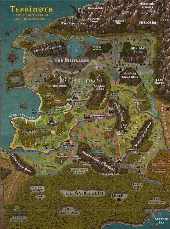
Political Map

By Skie, in Realms of Terrinoth

Hi everyone,

Have you came across (or created) a political map of Terrinoth? Which barony border each other, where the free cities are - that would be immensely helpful. For example, I'm planning to start my campaign in Frest and I know it borders Dhernas to the North...

Also, what scale would you put on the map. I know it's purposefully left without it, but what distances would you suggest?

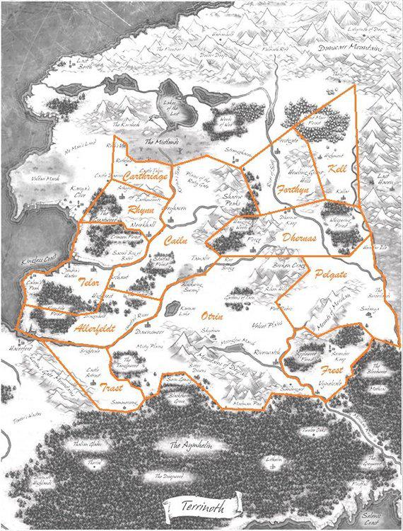
Using the map on page 140 of RoT and reading the descriptions for Terrinoth it is possible to work out where each barony lay; and the free cities are also shown on the map.

It is probably not necessary to demarcate the exact boundaries of the baronies, as medieval borders are not usually that clear-cut. I imagine that most inhabited lands will be within a few hours' walk from main roads, so each village will owe their allegiance to a particular baron, but the no-man's land between inhabited areas are really moot - if you are not taxing the people living there, or extracting resources, there is no need to designated whom it belongs to.

For distance, I looked at the climate zones on the map of page 4, and assuming that Mennara is Earth-sized, I assigned the top part of the map on page 140 as 60 degrees north latitude, and the bottom of the page as 36 degrees north - i.e. each division on the map margins is 2 degrees latitude/longitude, or 120 nautical miles.

This makes Terrinoth the size of (roughly) the Holy Roman Empire around (roughly) 1200 AD, which is what I imagine Terrinoth is based on.

Further, transferring the information to the Runebound Map (which I plan to base my sandbox campaign on), I am going to call each hex on the map 24 miles, which is a typical scale used for sandbox/hexcrawl campaigns based on D&D traveling time.

Those are the assumptions I used for my game. I hope to hear what other people have done.

Thanks.

I have done just a little bit of brainstorming of this. I think I'm going to go with a distance of 40 miles from Greyhaven to Nerakhall. I chose that as my baseline because they are the two free cities that are closes together.

That makes Terrinoth about the size of France.

Please can someone patient sketch this out :) I've got a lot to do in Terrinoth still!

Regarding the scale of the map I can atleast point to this post from the FAQ:

On 4/24/2018 at 2:26 PM, saethone said:

Question:

Hello, There are several beautiful maps in the Realms of Terrinoth book - however there is nothing by which to judge scale. Is there any sort of scale available so that rough distances can be determined?

Answer:

Hi Josh! We imagine Terrinoth (page 139) around 250 leagues across at its widest point (roughly 900 miles). Travel time in days is likely more an issue, and our benchmark is 5 leagues per day on foot on average. It probably would take 7 or so weeks to cross it on foot (3-4 on horseback), and several days to travel from Tamalir to Greyhaven that way. This is something the GM can change, though, to best fit the game and the plot. One GM might have Terrinoth as big as the US, another the size of Europe, a third eh size of France. And all are perfectly fine.

We’re discussing this here and may add some guidance along these lines either in a reprint or online. It’s a great question and thanks for bringing it up Josh!

Allthough I am not quite sure if by widest point they mean it literally from left to right or just the farthest points across. The latter seems to make the most sense however.

A smaller cartographer's supplement (maps) book would be awesome- the missing locations and some of the in-other-game maps could then be included (could have zoom in maps for cities and regions/ key areas/islands). Maps could have their scale with the proviso it can be changed as suggested above (although realistically you'd have to consider cities being smaller or closer together/further apart etc to fit the change if your campaign covered an area where such matters were relevant. For smaller-scoped adventures or one-shots it might not matter). If they check the places in the text are all on the maps that would also make for an even better toolkit (there are a few gaps at the moment) - and save having to make an educated guess or put it somewhere of your choice as the maps don't answer that question, and the reverse of this it's good having places on the maps not in the text that suggest their own stories, I've had some fun with this. So some maps with locations and 'empty areas' just giving indications of the terrain/landscape/urban or rural nature of them would be a nice touch- then there's still space for players to add their own lore to the canon.

Small supplemental books like this could expand on things- maybe with some adventures/ full campaigns alongside them- and not be too expensive.

Whilst Genesys is kind of a do it yourself any setting you want RPG (which is one of its best points) it is still going to benefit loads from FFG making some pre-cooked content for it as that allows players to just dive in to an adventure, as I'm finding it's a huge amount of work- well worth it but a lot of time- making an adventure, and the alternative of doing it all on the fly could slow down sessions in play somewhat and be quite challenging at times if you're trying to match things to the rules/core toolset, again hopefully FFG will produce some more adventures similar to 'The Haunted City'. Then you've got plenty to hand if you need it on the spot.

They could even make some more sourcebook content for official pre-gen characters from those in the Terrinoth games to go with what we have thus far (both NPC's and PC's), like Descent has its heroes and monsters collection a book expanding on these as there's still plenty of potential in those games. I'm still planning on doing this and the Terrinoth game characters have some delicious scope for linking them and their unique aspects to Genesys skills, talents and so on but as I found with my character build it's a lengthy process. Again players can tweak these as they wish or self-build anything we don't have yet in Genesys but it would be good for FFG to do an official one so there's more to work with character-wise for those wanting ready-to-play material, I think and hope we'll get this kind of add-on in future.

Sometimes you just want an adventure at hand ready to pick up and play, the self-build approach means some play has to wait 'til you've cooked it! So having both options would be epic!

13 Major cities: 4 in Runebound 3: Riverwatch, Forge, Tamalir & Dawnsmoor and Descents: Valynedale, Nerekhall, Greyhaven & Frostgate. The other 5 are on the mat for heros of terrinoth.

That is the baronies I think. Nerekhall being a little charred after Garland Marklace. A proper map would be brilliant though.

Edited by Dburns41866

Someone in the "Terrinoth Explorers" Facebook group took a shot at making a political map. Thought I'd share.

46472449_2027396183966235_38121882629827

and of course following on from that really useful map remember the vacant thirteenth barony which I guess covers the area around the Mistlands? - will anyone ever risk taking up Waiqar's seat on the council? Or will Waiqar return and demand to claim it......

Does this thirteenth barony remain unnamed in ROT or is it ever named? Just realised that fact's missed my spheres of knowledge. If unnamed maybe we should decide on potential names for it, lest we ever want to make use of it!

Edited by Watercolour Dragon
On 10/15/2018 at 11:18 PM, Dburns41866 said:

13 Major cities: 4 in Runebound 3: Riverwatch, Forge, Tamalir & Dawnsmoor and Descents: Valynedale, Nerekhall, Greyhaven & Frostgate. The other 5 are on the mat for heros of terrinoth.

That is the baronies I think. Nerekhall being a little charred after Garland Marklace. A proper map would be brilliant though.

No- some of these may fall within the baronies, others are free cities (which ROT explains, sort of independent of the baronies). The baronies are those marked on the map- Carthridge, Frest etc

Full list in the order they're referenced in ROT

1. Trast

2. Otrin

3. Frest

4. Dhernas

5. Kell

6. Pelgate

7. Allerfeldt

8. Cailn

9. Telor

10. Carthridge

11. Rhynn

12. Forthyn

13. (Waiqar's vacant council seat) [The Mistlands] usually just called 'The Thirteenth Barony', not yet clarified if it had another name prior to being known as The Mistlands

I'm sure it had another name at some stage but I could imagine the name being struck from all records and the mere mention its name being considered to bring with it a curse or at least bad luck.

Due to this the name has been lost over the centuries, although it may still be referenced in some obscure, long forgotten text.

15 minutes ago, Suneisha said:

I'm sure it had another name at some stage but I could imagine the name being struck from all records and the mere mention its name being considered to bring with it a curse or at least bad luck.

Due to this the name has been lost over the centuries, although it may still be referenced in some obscure, long forgotten text.

That's a nice idea to work with, maybe the name being used is linked to some negative event that follows (but of course you'd have to never actually tell the real name to keep the mystery)

Jokingly maybe it's called Macbeth!

On 11/28/2018 at 3:21 PM, broknsword said:

Someone in the "Terrinoth Explorers" Facebook group took a shot at making a political map. Thought I'd share.

46472449_2027396183966235_38121882629827

Is there an actual link anywhere to this?

OK, went from the book descriptions of the boundaries of each Barony, and this is as close as I can figure it...

Terrinoth-Political.jpg

5 hours ago, IamGazrok said:

Is there an actual link anywhere to this?

I think it was Bryan Gibson. This is what he posted today. We're both fairly close to our reading of it.

65010501_2346206002085250_2031080490861068288_n.jpg

I posted take two on the Terrinoth Explorers group, too big a file to post here.

I came up with this as a more simplified version. I think this final version better reflects all of the reference points and text descriptors of the various places. The one issue that is still difficult to resolve is that it states Forthyn goes down to the Broken Crags (but this is impossible as the main seat of Dhernas would then be in Forthyn territory), so I think they actually mean that it goes that far south longitudinally, but doesn't actually touch the Broken Crags. Baronies-Political3.png