 So i've been wanting a map of Averheim for The Enemy Within game we are starting this week. There wasnt one, so i took a stab at making one. Here is what i have so far. If you guys have any suggestions for locations to add to it, please let me know.
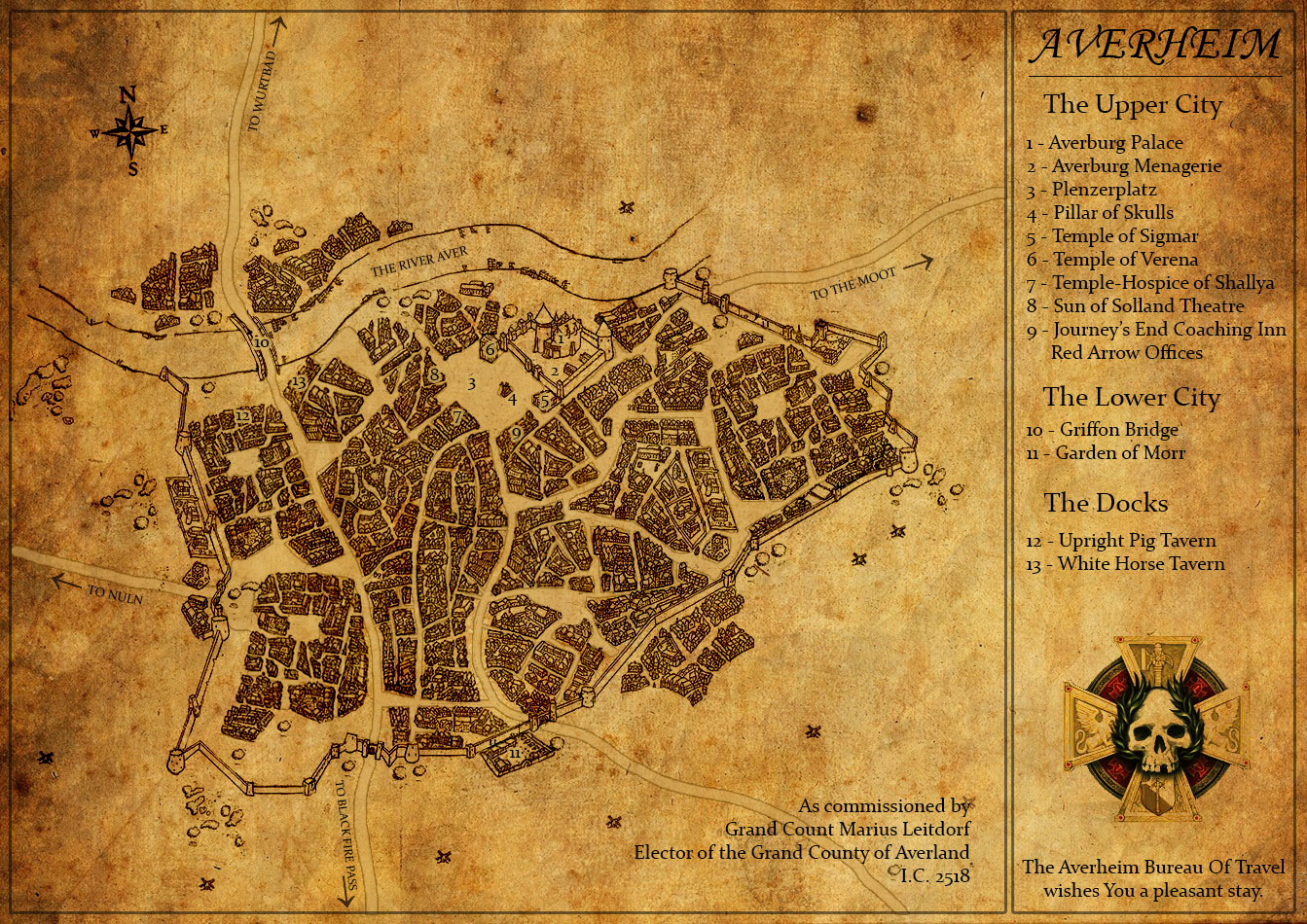
Avernheim City Map
Okay so my post was kinda wonky, the link to the source file is here: http://www.gitzmansgallery.com/maps/Map-City-Averheim-1.jpg
Nice looking map. Very much what I had in mind also. Should the Palace be in a hill/cliff-side?
I did collect some list of places from Averheim few years back. I'll try to find that list - It probably has few new sites to your map. Swords of Justice, Swords of the Empire (and there is third one also I think) novels might provide some places/info about the place also.
Funny - For some years I have hoped that someone would have energy to do little project about Averheim. Now, suddenly, these are just coming. You should check this topic from the StS forum: Averheim Project
That's an AMAZING job ! Congratulations Gitzman !
This Weekend, I've read Jackdays' Storm Of Chaos Timeline using Gitzman' super massive Warhammer map so as to prepare the Enemy Within Campaign with my usual player interpretating new characters (the previous made every adventure published yet and just arrived in 5th career, an epic 60 sessions run).
GITZMAN's Averheim map and big map, and JACKDAYS' timeline are sure superb tools to do the GM job in Enemy Within, and So is VALVORIK's thread in GM section about his preparations and thoughts.
I've noticed the 2nd Edition's 3 tomes "Damnation" campaign should be a nice way to continue after Enemy Within so as I don't expect so much new stuffs from FFG now in 3rd edition.
It looks really nice and fills a niche I have been thinking about too.
Some questions still remain though:
- Its supposed to be a black market area to the north of the river
- There is supposedly the docks which are not on the rocky bluff "Unterstadt"
- There is the city proper with walls and the like on the rocky bluff.
So the rich within the walls, the poor without, the criminals north of the river, overexaggerated of course.
This made my morning; thanks for making this, looks great!
Awesome, just awesome.
Over at the Liber Fanatica - The Averheim Project. We have also designed a map that will go with the source book for Averheim. The source book will be mutli edition. So anyone intrested in doing some writing for locations within the city then PM me pls.
Looks good. I agree with Araxosch about making the rocky bluffs more a prominent part of the map, since they are such a distinctive feature, and so much of the city is built around them being there.
From a purly stylistic (and somewhat pedantic) perspective, you may consider swapping up the typography a little. The face you are using for the descriptions is a little too Modern with very hard-edged serifs and dynamic contrast. Take a look at some Old Style faces, like Centaur or Garamond, or even some early Transitional like Caslon, Bell or even Baskerville (Caslon is the goto for most WFRP I've noticed). For the title, "Averheim," you may want to move away from an italic/script and look at either a roman in the faces above, or a Blackletter. In either case, kern it.
Other than a few type-nerd petty gripes, though, it's very well done.
Here is list I made for my campaing years ago. Places are mostly collected from the various sources. There could be some fan-made there also. Also I think The Orc Head Inn is mine, maybe? I just have faint memory creating it inspired by the picture from the Realms of Sorcery (WFRP2) adventure (which happens in the Averheim by the way).
Offcourse large settlement like this sponsors much more places like various guilds. But these I collected from various sources.
Districts:
- Merchant's Quarter
- Kleinmoot (this should be big, Averheim is close to Moot)
- Larswald District (poor district)
Gates:
- Southern Gate
- Western Gate
- Aversburg Fortress
- Ferry (across the River Aver)
- Stockyard & Slaughterhouses (close to the ferry and the river)
- Plenzerplatz & The Pillar of Skulls
- Chapterhouse of the Order of the Black Bear
- Chapterhouse of the Knights of Sigmar's Blood
- Red Arrow Coaches
Holy Places:
- Temple of Myrmidia
- Grand Temple of Averheim (Sigmar)
- Temple of Shallya
- Temple of Verena
- Shrine of Taal & Rhya (outside the city)
- Chapel of Morr & Graveyard (outside the city)
Inns & Taverns:
- The Upright Pig (tavern/low; gansters, poor district, close to docks)
- The Virtuous Mermaid (tavern/low; docks)
- The Lost Whaler (inn/low; docks)
- The River's Secret (inn/high; not so close to docks next to some platz)
- The Maid's Fancy (tavern/moderate; close to the southern gate)
- The Orc Head (inn/moderate; almost in the Plenzerplatz)
Guilds:
- The Salter's Guild
- The Vintners Guild
- Workshipful Guild of Legalists
- Physician's Guild
Great Map Gitzman. Really Good.
Wow, nicely done!
Is the RDP going to record the Enemy Within sessions? If so, I am very much looking forward to listening it.
Cheers
Philippe
Nice work.
jh
If you want to use the source, the Swords books note:
Griffon Bridge is one of several bridges not the only one.
in addition to the upper city "Plenzerplatz" there is also a Vormeisterplatz, where cattle droves can be brought in to auction.
Using Enemy Within inns also include
Sword of Sigismund - halfling chef, good wine, a place for officers to drink, lower city
White Horse - shady dock inn (lower city)
Journey's End Coaching Inn (Red Arrow Line) Plenzeplatz (upper city)
Rob
Great looking map! Well done!
Now I have a general question: why do city maps in WFRP never show any defences on the riverfronts?
An invading army would just need a few boats to be able to take Averheim by the river!
The Altdorf map is the same, but at least, it occupies both sides of the Reik. I always supposed some kind of chain and winch system could block off river traffic in case of attack…
Any ideas or explanations welcome!
Yes RDP is running The Enemy Within. We did character creation and backgrounds last week (availabel to listen to at RecklessDice.com) and are doing session one tonight. This was the primary drive behind getting some kind of Averheim map up and running, i needed it for our campaign.
Gitzman
What an amazing piece of art Gitzman, thanks for sharing this. Did you use some special software to create the map or is this pure Photoshop?
Nice Job! and Perfect Timing. We are getting ready to play this, building characters this weekend and probably starting play the next. It'll be interesting to hear how your group plays through it at the same time we're playing.
Thanks Again!
Jericho said:
Great looking map! Well done!
Now I have a general question: why do city maps in WFRP never show any defences on the riverfronts?
An invading army would just need a few boats to be able to take Averheim by the river!
The Altdorf map is the same, but at least, it occupies both sides of the Reik. I always supposed some kind of chain and winch system could block off river traffic in case of attack…
Any ideas or explanations welcome!
Yes in Nuln they use chains. Also boats are weak attacking a river front that is most likely to have cannon and their own boats. So an attacking army would have to use the tatic of mass to over come via river I would have thought.
Lets also not forget that an army to gain access to the rivers of the Empire would either have to come from within the Empire, or break though Marienburg, which houses the bulk of the Imperial fleet. Large scale river combat should be few and far between with the exception of river pirates and the like.
Gitzman said:
Lets also not forget that an army to gain access to the rivers of the Empire would either have to come from within the Empire, or break though Marienburg, which houses the bulk of the Imperial fleet. Large scale river combat should be few and far between with the exception of river pirates and the like.
Cities like Averheim and Nuln have been invaded by HUGE Greenskin Waaaghs! over the history. Probably Greenskins have used the rivers also… But these are past. And very rarely there is large enough invasion that can advance through the country and then start large scale siege (which will take time).
One more thing to considere in the map - Sources tell that Averheim sits on a bluff above the river. And this means really above, because city is immune to any regular floods that very much cause problems all over the province (low lands). Averburg sits on the highest point (and has never fallen). Waterfront in the city is probably short and rest of the city lies much higher from the river. Could there be even small cliff most of the way?
If one assumes a city is more "brass" than "silver/gold", the lower city below the bluff is larger than upper city.
The Enemy Within (new one) states the lower city is the brass and upper city, 'on the bluff' is gold and silver (with Stirland slum across river to the north).
I think Griffon Bridge would be further east, as east side is stinky trades (which would dump into river) so there would be more built upriver of it.
There is currently an Averheim project over at Liber Fanatica. Let me know if any of you are interested.
What would be very handy are side-fill details from your "The Enemy Within" campaigns.
jh
This is a handy map. I'd like to do some pamphlets as well that appear early in TEW, but alas….time….
jh
I have done up versions of the pamphlets for anyone interested (pm email address).
The Bruckberg Strasse, the street running from Griffon Bridge, is supposed to lead to the Plenzerplatz, implicitly going up onto the bluff on which the Plenzerplatz is located. (EW 3rd)
Logically the Averburg stands on the bluff, overlooking river. The Plenzerplatz south of the Averburg whose wall runs its entire northern edge (EW 3) so the map looks okay on that front and where the locations are around it - it's just the relationship to road and needing a bluff to mark the demarcation of brass from silver/gold.