Super huge detailed map of The Old World

By Gitzman, in Warhammer Fantasy Roleplay

Dudes,

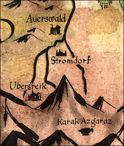
I've just come up for air after hours of Photoshoping. I've managed to compile a series of maps (22) of the Warhammer Old World into a single continuous map.

The map is roughly 65" x 54" at 300 dpi. The file size is 16.7 mb (.GIF wrapped in a PDF)

It includes an enourmous amount of detail including every river, city, town, mountain range, pass, etc from as far North as Troll Country, to as far South as The Pirate Isle of Sartosa. And as far East as the edge of The Empire, and as far west as Estalia.

  • Altdorf Region
  • Averland
  • Border Princes
  • Bretonnia
  • Kislev
  • Nuln
  • Estalia
  • Hochland
  • Middenland
  • Nordland
  • Ostermark
  • Ostland
  • Reikland
  • Stirland
  • Suddenland
  • Sylvania
  • Talabecland
  • The Moot
  • The Pirate Isle of Sartosa
  • Tilea
  • The Wasteland
  • Wissenland

This is not my original artwork, but instead the completion of a long term project of compiling all these maps into a single cohesive megamap.

Its a large file, and all that, so beware =). But its very cool.

Original credit for the artwork of the individual maps and cartography go to Andreas Blicher and Alfred Nunez, Jr.

Visit Gitzman's Gallery - WFRP Maps to download.

Game on,

Gitzman

Was this really necessary? I mean don't you have a new baby and we're perfectly comfortable with 8x11 maps completely devoid of detail or accuracy. You're just going to step on someone's toes here and nobody appreciates a show-off. [wink, wink]

I hope it looks good. I'll let you know after it gets done downloading ;) I've traditionally used those very maps in the service of my games and campaigns.

Jay H

They just fit so nicely together, like a puzzle (well some of them, some put up a good fight)... it had to be done. Besides, who doesnt love a friggin' gigantic Warhammer map that has more detail than you know what to do with? Now you can trace your adventure all the way accross The Old World across hundreds of miles without loading a new file (assuming your computer doesnt explode handling a 350 mb PDF).

Gitzman

Okay so i decided that 350 meg PDFs were not the best way to handle this =). I've posted an optimized .GIF file wrapped in a PDF which is around 16.7 megs for a 19,800 px by 16,200 px image. A little mor reasonable i think. Enjoy.

Gitzman

Just plain lovely!

I had weird plans of doing something similar myself... but my photoshop-fu is rather weak.

This will look great when printed on a huge paper!

Many many thx!

yea i was hoping to print it out huge too, but i dunno what Kinkos would charge for something like that, an arm and a leg at least =)

Gitzman

Gitzman, you're awesome. Thanks for your hard work. I know that some of those maps don't want to line up right at the edges, and I think you've pieced them together very well.

To print it, I'd recommend taking it to a blueprinting (reprographics) shop. They should be able to print a PDF in large-format black and white for just a couple of bucks per sheet. Ask them to print it on their widest white bond paper (which will be somewhat flimsy, but affordable). They'll probably have other paper color options, but more than likely they will be pastels.

There might be a minimum price order (usually around $5) so find out how many prints you can get. If you want to have it printed on sturdier paper, find out what they've got and what they're charging for it. A big map on presentation-weight paper could cost $15 or more, but it wouldn't hurt to ask. Bring in the PDF on a flash drive, and don't be surprised if you're told it will take a couple of hours to complete your order.

By Nurgle's feculent corruption, that thing is a work of beauty and should be put in a gallery.

jh

Thanks dudes, it was a LOT of work to make that thing come together. I called it a puzzle, but only 3 or 4 pieces fit =).

I love those ideas on printing, im going to try that some time soon i think. Though i'll probably add some more flare to the outer design before printing it up. Its still a little dry for my taste. need to find some high resolution swirlies and flourishes.

Gitzman

By Ulrics beard this is a masterpice.... I can't get my head around it sorpresa.gif

All I can say is... AWESOME WORK !!! aplauso.gif I i would also like to thank you for all your wfrp3 material it's just brilliant keep up the awesome work :D

Gitzmen, the map is really, really impressive. I am exploring regions that I never even heard about thanks to your map! aplauso.gif

Gitzman,

You sir, are a scholar and a gentleman. Thank you very much for this. Our group has been using the smaller maps for journeying and having a joined-up version like this is incredibly helpful. Sincere thanks.

Monkus

Im so glad you guys are enjoying it.

I've ,managed to locate another 10 or 15 maps which i'll be adding to the site soon. Sadly they are not the same artist/format as the ones in the Mega Huge Map, so it will not be growing any time soon (that is unless someone finds me a map i dont aleady have there =)).

Gitzman

Very nicely done! Now where to get it printed out.

Do any of you know a quick and easy way to mark a group's travels on such a map? Sort of like what googlemaps can do, plotting a course or something?

That would be excellent.

Wow, really nice work!

Actually, yes. Since its on a PDF you can use the commenting tools to draw all over it.

These tools are not available when viewing the PDF via the web browser, so you'll need to save the file to your computer then open it up again. Under the 'Comment' tab, 'Show Comment & Markup Toolbar' and you will be given a series of drawing tools.

Alternativly you can use the 'Sign' tab and 'Apply an Ink Signature' which essentially lets you draw with a red pen all over.

Once you've made drawings/notes to the map, save the document to save them. They remain movable and editable in a second 'Comments' or 'Signatures' layer and will not overdride the map graphics.

Hope this helps.

Gitzman

Thanks Gitzman, will try this at once.

By the way, I can't find Stromdorf or Karak-Azgaraz

whf04map.png

I'll see what i can do.

There were a few 'casualties' during the merging of the maps. It is entierly possible that some cities 'may' have been whiped off the map (accidently).

If so, i can try to replace them, but some just didnt fit. And given the scope of the map, im okay skippign some.

However, that being said, some cities are quite important =), and the ones you mentioned im quite fond of so i'll try to get them back in, in the next update.

Game on,

Gitzman

You know.. after looking at the map, i found Ubersreik, its just south of Altdorf. I compared locations to the map you showed me (and what FFG is using for the WFRP3 products). It appears a few 'adjustmetns' to the maps have been made to accomodate the new tow (Stormdorf & Karak-Azgaraz).

I'll try to add Stormdorff and Karaz-Azgaraz into the next update, though the structure of the map will remain the same.

I did not include all the Dwarf settlements as this was mainly intended as an imperial map, but perhaps that is something i can look into as well.

Gitzman

I thought that those Stromdorf and Karak-Azgaraz was missing because you might have been using 2nd and 1st edition materials. Those are new, created by FFG to use as a starting point for new players. They wouldn't have been included in the maps floating around the internet because they are rather new, but are also rather important because these are the locations that FFG will build upon (well, besides Stromdorf. I don't think it's going to be featured in any other products besides gathering storm). I do however believe that the new Dwarf Box is going to feature Karak-Azgaraz.

Anyway, the map is awesome as it is. I am already using it to plot the adventurers path. Can't wait for the update.

Thanks again for your effort!

Wow! I love maps and I love your map!

/M

Gitzman said:

I'll see what i can do.

There were a few 'casualties' during the merging of the maps. It is entierly possible that some cities 'may' have been whiped off the map (accidently).

If so, i can try to replace them, but some just didnt fit. And given the scope of the map, im okay skippign some.

However, that being said, some cities are quite important =), and the ones you mentioned im quite fond of so i'll try to get them back in, in the next update.

Game on,

Gitzman

Your map is combined from the works of Black Spectrum maps (meaning Andreas Blicher), right? And Blichers work is basicly based on the works of Mad Alfred. Now, Blichers map were done about time of WFRP2, but Mad Alfreds maps WFRP1 time. During WFRP1 there were limited amount of sources compared to current date and version. Mad Alfred did HUGE and great job detailing the world back in the day, when maps were so limited... BUT the Warhammer world has changed ALOT since - And WFRP3 has bring even more changes and new places. Good example - Just check Kislev and compare the "Realm of the Ice Queen" (WFRP2) maps...

Here's lates from Andy, which details Reikland with these WFRP3 places (first draft, and might need little adjustment): Hapimeses Gallery - Southern Reikland

www.WFRP.it I think compined Empire maps first time and after that there was even colored version about this compo. But I dont know are those available anywhere anymore...

****, this is one awesome map! I'm just a bit sad that it's a bit CPU intensive (at least on my not-so-good laptop). Maybe saved as another format than PDF, or with another program than Acrobat, it can be less laggy when browsing?

Really outstanding work! Very well done! Bravo!

It sounds like you are inclined to tinker. If so, please consider this suggestion. Rather than the Warhammer logo you used, switch to one that is more in a "wood-cut" style. Ditto for any other ornamentation. This will match up with the style of the map itself, and will look amazing if printed in brown ink on a vaguely vellum or parchment color of paper.

Cheers! Again, excellent!